Maritime History, Archaeology,
Coastal Science

Brief History of Brunswick Town
Prior to settlement, the Cape Fear was dominated by pine barrens – areas that were almost entirely excessively drained sands that supported little besides the long-leaf pine. An account from the 1663 voyage of William Hilton to Cape Fear featured in John Lawson's (1709) A New Voyage to Carolina noted that,"...in the lowermost Parts [there are] innumerable Pines, tall and good for Boards of Masts, growing, for the most part, in barren and sandy, but in some Places up the River, in good Ground, being mixt amongst Oaks and other Timbers." Following Parliament's passage of the Act for Encouraging the Importation of Naval Stores from America in 1704, the combination of bountiful natural resources, a mercantile economy, and use of an enslaved labor force enabled a wealthy planting class to produce large quantities of tar, pitch, and turpentine (a.k.a. naval stores) for export to Europe. While there was a good profit for planters to engage in the naval stores trade, the lands did not support extensive cultivation, which ultimately hindered the later expansion of rice and other agricultural exports in the region (Trinkley and Hacker 2016: 64-65).
In 1712, two sons of former South Carolina Governor James Moore, Col. James Moore II and Capt. Maurice Moore, led a militia force to suppress the Tuscarora Indians in North Carolina. The South Carolinians, led by the Moore brothers, defeated the Tuscarora at Nooherooka on March 23, 1713. Following his involvement as militia captain, Maurice Moore elected to stay in North Carolina and purchased land in Edenton along with waterfront properties in Beaufort (La Vere 2013: 178-180). During the Yamassee War in 1715, now Col. Maurice Moore was sent to aid South Carolina against Yamassee raids near Charles Town (Charleston). On the march to Charles Town, Moore needed to cross the Cape Fear River at Sugar Loaf, which was the site of a Cape Fear Indian settlement. Upon receiving advance warning of an impending raid by Waccamaw and Cape Fear Indian war parties, Col. Moore’s troops preemptively attacked and defeated the tribes before crossing the river. This action, along with the wars it stemmed from, removed Native American presence in the Lower Cape Fear and paved the way for European colonial settlement. The attack of the Indian settlement at Sugar Loaf also introduced Col. Moore to the vast potential of the Cape Fear region as a prospect to increase his personal land holdings.
As early as 1720, colonists had increasing difficulty acquiring land in South Carolina. High taxes and centralized government in Charleston enticed many to look to North Carolina for property, especially in the Lower Cape Fear. Early colonial policies were drafted to make land acquisition both inviting for settlement and profitable for the Lords Proprietors of the Carolina Colony (and later the Crown). Blatant opposition of proprietary policies along with disregard for the enforcement of those policies during Royal Governor George Burrington’s administration (1724-1725, 1731-1734), allowed settlers like Maurice, Roger, and Nathaniel Moore, Edward Moseley, John Baptista Ashe, and Eleazer Allen to accumulate vast land tracts in the Lower Cape Fear region (Wood 2004: 51). These men were connected by family ties resulting from their marriages into the Alexander Lillington family of Perquimans County and the William Rhett family of Charleston, South Carolina. Living on plantations scattered along the Cape Fear and the Northeast Cape Fear rivers, they maintained an active interest in and concern for the success of Maurice Moore’s future town-building venture at Brunswick.
From 1724 to 1725, Gov. Burlington explored the Cape Fear area in an effort to create a development plan. On June 3, 1725, Col. Maurice Moore was granted 1,500 acres on the west side of the Lower Cape Fear. He immediately set aside 320 acres with a portion being divided into half-acre lots of 82½ feet in width by 264 feet in depth. A total of 24 blocks were laid out, each with seven lots across and two lots deep. Roger Moore, who also purchased numerous properties in the Lower Cape Fear, added 20 lots to the northern edge of the town plan, which brought the total to 356 lots (Lee 1952: 239, South 2010: 2). Lots were identified for a courthouse, church, cemetery, markets, and common areas for the public.
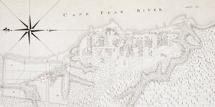
The town was situated on a low bluff on the western bank of the Cape Fear River approximately 12 miles north of the river's mouth. Trees were cleared in a wide area around the town (Andrews 1921: 282). This location, seven miles below a shoal in the Cape Fear River called ‘the Flats,’ ensured that large oceangoing ships would be able to trade at the port – contemporary descriptions of the river note that ships with draughts deeper than 9 feet could not navigate over the Flats (Andrews 1921: 279). In 1729, Brunswick was selected as the seat of New Hanover Precinct, established that year, and in 1731 British authorities designated Brunswick an official port of entry (Wood 2004: 15). The anchorage was, "within half a musket shot from the town," and ships could make it from the river's entrance to Brunswick in 3 to 4 hours (Andrews 9121: 282). A courthouse was built in the town, church and government elections were held there, as was precinct court.
Despite the establishment of a rival port at Newton (Wilmington) above the Flats, the residents and prominent families of Brunswick continued to exert considerable influence in the colonial government. By the mid-18th century, Wilmington, due to its location at the forks of the river, developed as the trading center for the surrounding area, while Brunswick existed chiefly as a shipping point for naval stores and forest products meant for the British mercantile trade (Lee 1952: 54). Port Brunswick, including both Brunswick Town and Wilmington, accounted for over 70% of naval stores exported from the American colonies in the 18th century (Outland 2004: 13, 31). This trade was made possible through a sizable enslaved population. In 1767, the Lower Cape Fear plantation society included approximately 4,216 residents, 63% of which were enslaved (Wood 2004: 99).
Royal Governors Arthur Dobbs and William Tryon both lived at Brunswick from 1758 to 1770. Their residence, an estate called Russelborough (originally built by the captain of HMS Scorpion, John Russell) was located north of the town limits. Janet Schaw wrote in 1775 that Brunswick was the best seaport in the province, but the town consisted of, “a few scattered houses on the edge of the woods, without street or regularity… inhabited [mostly] by merchants” (Andrews 1921: 145). A large percentage of the port town was burned by British soldiers under the command of Captain John Collett in 1776 during the American Revolution.
In June 1726, Maurice Moore made a town plan of Brunswick, and another was made by the assembly in 1745, however neither of these maps survive. The port town's layout is primarily known from the 1769 drawing by C.J. Sauthier (Lee 1952: 238-239; see above image). According to research by E. Lawrence Lee (1952: 230) who reconstructed the town lots, Brunswick Town proper had 10 to 12 houses in 1731, and only 20 families by 1754 (compared to 70 families in Wilmington). Sauthier’s map indicates about 35 residential buildings near the zenith of Brunswick's development in 1769 (Lee 1952: 230). Archaeological excavations by Stanley South in the 1960s that followed Lee's findings has confirmed the accuracy of Sauthier's map.

The Sites

Wharf 01 (31BW376**13)
Roger Moore's Wharf


Wharf 01 is a wooden timber-crib wharf at the northernmost end of the historic site, at the headland of Governor's Bay. The map drawn by C.J. Sauthier in 1769 shows the wharf in a state of disrepair, suggesting it was no longer operational at that time. Based on Lee and South's recreated lot plan, the wharf is located on a waterfront property initially owned by Roger Moore (Lot 337). Maurice Moore assigned his brother the deed to lots 337-351 on 11 December 1728, and these were the second lots sold in the town (the first was to Cornelius Harnett in 1726. See Lot 23; Wharf 03).
Roger Moore was a colonial official, lawyer, and land speculator in South Carolina. After the death of his first wife, Mary Raynor, in 1721 he married Catherine Rhett, daughter of Col. William Rhett who famously captured the pirate Stede Bonnet at Cape Fear. Taking a notable interest in seeking land grants in the Lower Cape Fear, by 1727 Roger had accumulated more than seven thousand acres of property and four years later he owned nearly twenty-five thousand acres. Moore moved from South Carolina to North Carolina around 1731. By this time he had built a brick plantation home, Kendal, located 2 miles above Brunswick Town and a year later had also built the opulent estate at Orton which was his primary residence (Sprunt 1958: 7; Trinkley and Hacker 2016: 64).
A traveler who visited Moore at Kendal in 1734 described him as, "the chief gentleman in all of Cape Fear" (Anonymous 1737: 43). Moore held a number of provincial and local offices in North Carolina. He was assistant justice of the General Court in 1732, a justice of the peace for New Hanover Precint in 1734, a commissioner for the boundary with South Carolina in 1735, and a member of the Royal Council from 1734 until his death in 1751. At the time he wrote his will, he owned over 20,000 acres of land along with 250 slaves across his various holdings (Trinkley and Hacker 2016: 74). In his will, he specifically mentions the enslaved carpenter, Higate, which is indicative of the skilled roles enslaved people played in the plantation export system centered around naval stores and barrel-making. It is probable that carpenters like Higate were also utilized in constructing the wooden wharves at Brunswick Town. The wharf built on Moore's waterfront lot at Brunswick likely served as the primary medium of exchange for his plantations at Kendal and Orton and initial landing for the port town.
Archaeological observations suggest that Wharf 01 is a timber-crib style wharf that extends in a northeasterly direction from the southern headland of Governor's Bay. Much of the structure is buried under scattered ballast fill, and the site is partially cut off on its outer end from the installed wave attenuation devices. Exposed timbers suggest that a single break and crib lay between the current marsh extent and wave attenuators. The stretchers and single header measure an average of 11-12 inches in diameter. The longleaf pine logs are unhewn or roughly hewn, with the single header measuring over 20 feet in length. A single cross timber bisects the exposed crib. The cribbing timbers are secured together using saddle notch joints with a trunnel. An interesting feature on one of the stretchers forming the break between cribs is an inscribed Roman numeral "III" on the upper face of the log. This potentially reflects marking individual pieces of wood for use in the wharf's construction.

Wharf 02 (31BW376**15)
William Dry's Wharf


Wharf 02 is a wooden wharf likely built as more residents moved to Brunswick Town in the 1730s or 1740s. The map drawn by C.J. Sauthier in 1769 shows the wharf in a state of disrepair, suggesting it was no longer operational at that time. The wharf was built on the waterfront lot (Lot 36) owned by William Dry II and his family until 1766. In 1720 Dry married Rebecca Moore, Roger Moore's twin sister (Gregg 1975: 192). Dry moved his family to Brunswick Town in 1736, where he purchased lot 36 from Col. Maurice Moore in June 1738 (Walker 1958: 5). During his tenure at Brunswick, Dry served as justice of the peace, militia captain, and was a prominent merchant in the town prior to his death in 1740 (Trinkley and Hacker 2016: 58). His son, William Dry III inherited his waterfront property and ownership of the wharf as well.
William Dry III retained his father's magistrate's office and militia command, and in 1748 led the militia in a counteroffensive to repel the Spanish raiders aboard La Fortuna (South Carolina Gazette 1748). For this, he was promoted to the rank of colonel in the militia. He served as a justice of the peace after 1738, King's customs collector and commissioner of pilotage for Port Brunswick around 1753, commissioner of Fort Johnston (1754), commissioner of roads in the southwest district of New Hanover County (1745–64), Wilmington town alderman in 1760, member of the General Assembly from Brunswick in 1760 and 1761, and a member of the governor’s council from 1764 until 1775 when he was suspended because of his revolutionary stances (Watson 1973: 1-3). His plantation just above Brunswick Town, Bellfont (formerly Russellborough), which he acquired from Gov. William Tryon in 1771, was burned along with most of the port town by British forces under the command of Fort Johnston's officer Capt. Collett during the American Revolution (South 1967: 365; Virginia Gazette 1776: 3).
Wharf 02 is a timber-crib style wharf that projects approximately 100 feet eastward into the Cape Fear River. The known structure is composed of 6 interconnected cribs, or solid boxes, measuring 20 feet by 24 feet with 6 foot breaks between each crib. The structure is composed of longleaf pine logs measuring an average of 12 inches in diameter. Joinery used to connect headers and stretchers included lock-notching on lower courses, as well as a combination of saddle notching with a trunnel and half-lap notching on upper courses. This formed a solid timber-crib boxed frame that was filled with ballast stones and earth. Cross timbers were used to satabilize the structure within the cribbing and were joined to the headers via 45 degree diagonal notches.
Archaeological investigations at the land terminus of the wharf indicated that the lower courses of headers were square hewn, with upper courses unmodified or roughly hewn on the top and bottom of the log. The cribbing in this location was floored with wooden planking oriented diagonally along the base of the crib (Byrd 2018: 42-43). Tar was noticed on the wooden remains, likely as an added layer of protection for the wooden surface or from leaks in naval stores barrels exported from the port. Artifacts recovered from the wharf date primarily from the 1720s to the 1770s, with a mean pipe stem date of 1759 using Binford's formula for measuring pipe stem bore holes (2018: 59). Additionally two tar kilns were discovered at the land terminus of the wharf, however researchers suggested that these predated the town/wharf (2018: 69).

Wharf 03 (31BW376**17)


Wharf 03 is a wooden timber-crib style wharf located on the edge of lot 26 and lot 25 in the southern waterfront district of Brunswick Town. Records indicate that lot 26 was initially conveyed to Quaker planter Richard Dunn from Col. Maurice Moore on 13 February 1731. Early Quaker settlers found their way into North Carolina’s Cape Fear River valley beginning in the 1730’s. Dunn was the founding member of the Eastern Quaker meetings at Dunn's Creek in the Upper Cape Fear, which lasted until 1772 when most of his membership moved to Cross Creek. Dunn sold lot 26 to James Lyon on 19 February 1736. James Lyon arrived in the Lower Cape Fear by 1735 and lived there until his death in 1752. He was a planter and mariner, as well as a justice of the peace and commisioner of roads for Bladen County. There is no indication if Lyon or Dunn ever settled on or improved lot 26 in Brunswick.
On 9 September 1735, Col. Moore sold lot 9 in Brunswick to John Martindale for £24. Based on the reconstructed lot plan by Lee (1962), lot 9 is not part of the current historic site. Martindale's 1752 will, however, transferred ownership of lot 26 to his wife, Susanna (McKoy 1969: 4). This indicates that Martindale likely purchased lot 26 sometime after 1736. Martindale was listed as the ferryman at Brunswick, and he likely took over this role from Col. Thomas Merrick in 1740 (Jackson 1996: 179). Susanna died in 1762 and left the property to her son Isaac Ray, who was married to Amelia Lord, the daughter of Brunswick ordinary/tavern owner William Lord (McKoy 1969: 8). Ray operated a ferry near Wilmington in 1761, and it is possible he continued operating the ferry on lot 26 in Brunswick as well (Walker 1958: 45).
In 1766, the General Assembly passed legislation requiring all ferries to establish an ordinary marked with an inscribed sign noting the structure's purpose so they, "may be the more readily and generally Known by Travellers and others" (Clark 1905: 728). While there is no documentation that Martindale or others built a tavern, the presence of a structure at the end of Wharf 03 on Sauthier's map suggests that this location might've fulfilled this obligation (see 31BW376**2). It is possible that the landing on lot 26 was maintained after 1762 by others who owned adjoining lots at Brunswick.
Wharf 03 is a timber-crib style wharf that projects eastward from shore to the original river channel. Two stretcher timbers of an outer crib were located. These contained evidence of saddle notched joinery to receive the headers and likely represent a break between cribs. At least 3 anchor pilings were observed within the outer crib to position the structure in place. Wharf 03 was uncovered by erosion of the overlying salt marsh sometime between 2017-2020. In 2021, the ballast fill was contained in the original square form of the wharf, as shown in the sonar data (Image 2). By 2024, the fill was disarticulated and scattered from dynamic wave energy.
Ceramics recovered in 2024 from the wharf fill and surrounding area include a barley-patterned creamware plate rim, a delft bowl with a written inscription on the interior, red coarse earthenwares, and stoneware sherds. Additional artifacts included a pegged leather shoe sole, pipe stem, glass liquor bottle base, a tongue-and-groove floorboard, as well as butchered cow and rib bones.
The wharf is aligned with site 31BW376**2 on the waterfront side of Front St. in lot 26. This site was partially excavated by Stanley South (designated S17) who found a stone and brick foundation with an associated building depression. Sauthier's map denotes a wall on the west side of the building similar to the one at the Public House. South's observations and recovered artifacts from this structure led to the tentative interpretation of the site as a warehouse. If correct, it was likely built around the same time as Wharf 03 to store goods to be shipped from the landing. Another possibility is that the structure served as an ordinary for the ferry, which was likely moved from lot 23 to lot 26 in 1742. More research is required to determine the association of this feature with Wharf 03.
Wharf 04 (31BW376**18)
Cornelius Harnett's Wharf


Wharf 04 is a wooden landing built on the water frontage of lot 23 in the southern district of the port town. The earliest property transfer recorded at Brunswick Town was on 6 June 1726, when Col. Maurice Moore sold lots 22 and 23 to Cornelius Harnett for £2 each. In an effort to prevent land speculation, a condition of the sale was that structures at least 16 feet by 20 ft. were to be built there within 8 months. Harnett, originally a merchant from Dublin, Ireland, appears in the documentary record of North Carolina at Chowan Precinct in 1723 (Ashe et. al. 1917: 200; Lee 1965: 118). Involved in public affairs, Harnett was allied with proprietary governor George Burrington when, in 1725, he and the governor attacked the home of Sir Richard Everard. To avoid pending criminal charges following the dismissal of Burrington to London in that year, Harnett joined the growing venture at Cape Fear to seek new prospects and rehabilitate his reputation (Watson 2014: 2).
Within the first year of owning lots 22 and 23 in Brunswick Town, Harnett presumably built homes on each lot, one of which was used as a tavern (Watson 2014: 3; see 31BW376*23*3). In 1737, he successfully petitioned the General Court in Edenton to establish a ferry across the Cape Fear River. The ferry was to operate, "from the place designd for a Towne on the West Side of the River [Brunswick] to a place called the Hauleover; And that he receive the Sum of five Shills for a man & horse and half a Crown for each person and that no person to keep any Ferry within ten miles of the sayd places" (Saunders 1886: 698). One year later, the ferry was operational and it is likely that Wharf 04, or an iteration of it, was built sometime between Harnett’s acquisition of lot 23 in 1726 and 1738.
The 1725 ferry established over Core Creek in Bath and Harnett's ferry at Brunswick Town completed the "King's Highway" (presently US Route-17), a route that stretched from Virginia to South Carolina (Watson 1974: 247). The first ferrykeeper was Capt. Edward Scott, who bought lot 29 at Brunswick Town from Nathaniel Moore in 1733 and built a home there (31BW376*29*2 [S28]). Capt. Scott resigned in March 1738 and was succeeded by Thomas Merrick in June of that year (Walker 1958: 4). Scott went on to operate Nath Moore's Front (31BW376*29*1 [S10]) where he was licensed to keep an ordinary (inn) in the lower part of the home in June 1741 (Walker 1958: 20).
Before New Inlet was formed by the hurricane of 1761, mariners approaching Cape Fear were required to sail close to the treacherous Frying Pan Shoals at the mouth of the river. To avoid any potential mishaps, sailors in small craft could use a narrow section of the sandy peninsula that separated the river and Atlantic Ocean to lighter vessels overland into the river, called the Haulover. A high dune near the riverbank located on the east side of the river across from Brunswick, named Sugarloaf, was used as a navigational marker for the haulover. This was the site where Col. Maurice Moore attacked the former Cape Fear Indian settlement in 1715. The settlement may have been occupied thereafter but was fully demolished by Roger Moore at the Battle of Big Sugar Loaf in 1725 as a response to an alleged Indian raid on Orton or Kendal plantation (Sprunt 1916: 14).
Col. Maurice Moore had acquired 3,000 acres of the Federal Point peninsula including "the Hauleover" in 1725, and in 1736 transferred 2,640 acres to Col. Thomas Merrick of Wilmington and the rest to John Porter (Jackson 1996: 106-107). Merrick operated the ferry across the river until September 1740, when the court accepted, "the resignation of Col. Merrick as a Ferry Keeper at Brunswick ordered to become effective within a month after this Court," provided it could find a proper person to keep the ferry (Walker 1958: 16). New Hanover County Deed records list John Martindale as the ferryman at Brunswick in 1752. Martindale had purchased lot 9 from Maurice Moore in 1735. In his will, however he left his wife, Susanna, water lot 26 in Brunswick Town, his real and personal estate, and two slaves, Maria and Peter (McKoy 1969). It is possible that Martindale settled in the town on lot 26 and operated the ferry after 1740 from that location. This would suggest that the ferry landing shifted from Wharf 04 to Wharf 03 by the mid-18th century.
Harnett continued ownership over lot 23 until his death in 1742. It is unclear if the property was sold or given to Harnett's son and heir, Cornelius Harnett II, who became a leading merchant, public official, and political leader for North Carolina in the American Revolution. While the ferriage likely moved to lot 26 at this time, the tavern Harnett built on lot 23 was a profitable source of income and it's possible that Harnett II continued to oversee operations there as the landowner. Wharf 04 and buildings on lot 23 were potentially converted to more suitably accommodate sailors engaging in the bulk shipment of naval stores. Sauthier's plan of the port town shows the wharf and associated structures were extant in 1769.
Wharf 04 is a timber-crib style wharf that projects eastward approximately 15 meters (50 feet) from the marsh line to the original river channel. The site is comprised primarily of ballast stone fill that is scattered in the general form of the wharf structure. Two timber elements of the wharf were located including a partial header on the north face of the wharf containing two saddle-notches along with a single stretcher near the marsh. Three barrels were found within the fill east of the stretcher . Barrels were also found in the fill of Wharf 02, and likely represents remnants of the naval stores trade that were used to help contain the loose stone fill in certain areas of the structure. It is possible that broken or deformed barrels were used as fill elements on wharf sites.
A large concentration of slate roof tiles were found on the outer edge of the scattered ballast fill, which extends to the north of the site. Other artifacts found within the fill included three clay pipe stems with one containing a partial bowl and initials "I. B." molded into the heel. During the colonial period, clay pipe makers would use "I" to denote the letter "J." Ceramics included coarse earthenwares such as North Midlands-type slipware, Buckley-type ware, as well as a green-glazed sherd and two redware sherds. Two Rhenish brown stoneware body sherds were also recovered along with a single refined earthenware blue on white porcelain sherd. Two 18th century dark green glass liquor bottle neck and rims were also located.
The wharf is located immediately to the east of a coquina stone building foundation at the edge of the upper marsh on lot 23 (see 31BW376*23*1). This potentially represents the original ferry house built by Harnett for travelers crossing the river at Brunswick.

Structure 01, Lot 23
(31BW376*23*1)
Possible Ferry House


The earliest property transfer recorded at Brunswick Town was on 6 June 1726, when Col. Maurice Moore sold lots 22 and 23 to Cornelius Harnett for £2 each. Harnett joined the Moore family's Cape Fear venture in 1725 after a falling out with his former ally, the proprietary governor George Burrington (Watson 2014: 2). In an effort to prevent land speculation, a condition placed on the sale of lots 22 and 23 was that structures at least 16 feet by 20 ft. were required to be built there within 8 months (Ashe et. al. 1917: 200; Lee 1965: 118). Within the first year of owning lots 22 and 23 in Brunswick Town, Harnett presumably built structures on each lot, one of which was used as a tavern (Watson 2014: 3).
In 1737, Harnett successfully petitioned the General Court in Edenton to establish a ferry across the Cape Fear River. The ferry was to operate, "from the place designd for a Towne on the West Side of the River [Brunswick] to a place called the Hauleover; And that he receive the Sum of five Shills for a man & horse and half a Crown for each person and that no person to keep any Ferry within ten miles of the sayd places" (Saunders 1886: 698). One year later, the ferry was operational and represented the final link for the "King's Highway" (presently US Route-17), a route that stretched from Virginia to South Carolina (Watson 1974: 247). In order for the ferry to operate successfully, it is likely that Harnett built a ferry house in association with the ferry landing (31BW376**18) on the Brunswick side of the river. The stone foundations found on lot 23, designated structure 01, are likely the remains of the original 1738 Brunswick ferry house.
The first ferrykeeper was Capt. Edward Scott, who was succeeded by Thomas Merrick in June 1738 (Walker 1958: 4). Merrick operated the ferry across the river until September 1740, when the court accepted, "the resignation of Col. Merrick as a Ferry Keeper at Brunswick ordered to become effective within a month after this Court," provided it could find a proper person to keep the ferry (Walker 1958: 16). New Hanover County Deed records list John Martindale as the ferryman at Brunswick in 1752, during which time the ferry landing might have moved north to lot 26.
Harnett continued ownership over lot 23 until his death in 1742. It is unclear if the property was sold or given to Harnett's son and heir, Cornelius Harnett II, who became a leading merchant, public official, and political leader for North Carolina in the American Revolution. While the ferriage likely moved to lot 26 at this time, the structures Harnett built on lot 23 were potentially converted to more suitably accommodate sailors engaging in the bulk shipment of naval stores. Sauthier's plan of the port town shows the wharf and associated structures were extant in 1769.
The visible remains of structure 01 on lot 23 are two coquina stone wall foundations on the northen and eastern sides of the building. There is a line of coquina that runs parallel to the eastern wall approximately 3 meters (10 feet) within the structure potentially represents a partition or room in the building. The northern wall was traced further to the west using a hand probe, but the full extent was lost due to the interference of surrounding vegetation. A single foundation stone was observed 7 meters (22 feet) south of the northern wall, which gives an estimated length of the building. These measurements place the structure within the dimensions required by Moore in the initial deed transfer to Harnett in 1725. If correct, this would make the ferry house one of the original structures built at the colonial port.


References
Anonymous
1737 A New Voyage to Georgia by a Young Gentleman. J. Wilford, London.
Andrews, Evangeline W. (editor)
1921 Journal of a Lady of Quality: Being the narrative of a journey from Scotland to the West Indies, North Carolina, and Portugal in the years 1774 to 1776. Yale University Press, New Haven, CT.
Ashe, Samuel A., Stephen B. Weeks, and Charles L. Van Noppen (editors)
1917 Biographical History of North Carolina from Colonial Times to the Present, Vol. 8. Charles L. Van Noppen, Greensboro, North Carolina. <https://books.google.com/books/about/Biographical_History_of_North_Carolina_f.html?id=rFbJq_5R4jcC>
Byrd, Stephanie
2017 The Curious Case of Construction: A Uniquely Built Wharf at Brunswick/Fort Anderson. Master’s thesis, Department of Anthropology, East Carolina University, Greenville, North Carolina.
Clark, Walter
1905 The State Records of North Carolina, Laws 1715-1776, Vol. 23. Nash Brothers Book and Job Printers, Goldsboro, NC. <https://docsouth.unc.edu/csr/index.php/document/csr23-0048>
Gregg, E. Stuart
1975 A Crane's Foot (or Pedigree) of Branches of the Gregg, Stuart, Robertson, Dobbs, and Allied Families. R. L. Bryan Company, Columbia, SC.
Jackson III, Claude V.
1996 Maritime history and survey of the Cape Fear and Northeast Cape Fear rivers, Wilmington Harbor, North Carolina, Vol. 1: Maritime history. Unviersity of North Carolina Press, Chapel Hill, NC. <https://digital.ncdcr.gov/Documents/Detail/maritime-history-and-survey-of-the-cape-fear-and-northeast-cape-fear-rivers-wilmington-harbor-north-carolina.-volume-1-maritime-history/2143404>.
La Vere, David
2013 The Tuscarora War: Indians, Settlers, and the Fight for the Carolina Colonies. Unviersity of North Carolina Press, Chapel Hill, NC.
Lawson, John
1709 A New Voyage to Carolina: Containing the Exact Description and Natural History of that Country. London. <https://docsouth.unc.edu/nc/lawson/lawson.html>
Lee, E. Lawrence
1952 The History of Brunswick, North Carolina: The Political and Economic Development of a Colonial Town. Masters thesis, Department of History, University of North Carolina-Chapel Hill, Chapel Hill, NC.
1962 Reconstruction of the Brunswick Town Lot Plan. Manuscript on file, Brunswick Town State Historic Site, North Carolina Department of Archives and History, Raleigh, NC.
1965 The Lower Cape Fear in Colonial Days. University of North Carolina Press, Chapel Hill, NC.
McCoy, W. B.
1969 Brunswick Lots Notes. Manuscript on file, North Carolina Department of Archives and History, Raleigh, NC.
Outland, Robert B.
2004 Tapping the Pines: The Naval Stores Industry in the American South. Louisiana State University Press, Baton Rouge, LA.
Saunders, William L. (editor)
1886 The Colonial Records of North Carolina, Vol. 2. State of North Carolina, Raleigh, NC.
Sprunt, James L.
1958 The Story of Orton Plantation. Wilmington, North Carolina. <https://archive.org/details/storyofortonplan00spru/mode/1up>
South Carolina Gazette
1748 Brunswick in North Carolina, September 23. South Carolina Gazette 24 October 1748 759:1-2. Charleston, SC.
South, Stanley
1967 "Russellborough": Two Royal Governors' Mansion at Brunswick Town. North Carolina Historical Review 44(4):360-372. <https://www.jstor.org/stable/pdf/23518003.pdf>
2010 Archaeology at Colonial Brunswick. Office of Archives and History, North Carolina Department of Cultural Resources, Raleigh.
Sprunt, James
1916 Chronicles of the Cape Fear River, 1660-1916, 2nd edition. Edwards & Broughton Printing Co., Raleigh, NC. <https://digital.lib.ecu.edu/16930>
Trinkley, Michael and Debi Hacker
2016 Archaeological Investigations at Kendal Plantation on the Lower Cape Fear River, Brunswick County, North Carolina. Chicora Research Series No. 74, Chicora Foundation Inc., Columbia, SC. <https://www.chicora.org/pdfs/Kendal%20Report.pdf>
Virginia Gazette
1776 New Bern, March 29. Virginia Gazette 6 April 1776 1287:3. Williamsburg, VA.
Walker, Alexander M.W. (editor)
1958 New Hanover County Court Minutes, 1738-1769. Manuscript on file, North Carolina Department of Archives and History, Raleigh, NC.
Watson, Alan D.
1973 William Dry: Passive Patriot. Lower Cape Fear Historical Society Bulletin 7(1):1-5.
<https://latimerhouse.org/wp-content/uploads/2024/01/Bulletin_1973_10.pdf>
1974 The Ferry in Colonial North Carolina: A Vital Link in Transportation. North Carolina Historical Review 51(3):247-260. <https://www.jstor.org/stable/pdf/23529021.pdf>
2014 The Other Cornelius Harnett. Lower Cape Fear Historical Society Bulletin 58(1):1-7.
<https://lib.digitalnc.org/record/250987?ln=en&v=pdf>
Wood, Bradford J.
2004 This Remote Part of the World: Regional Formation in Lower Cape Fear, North Carolina, 1725-1775. University of South Carolina Press, Columbia, SC.